The researchers from Berkeley University present a baseline method to improve access to SAR (Synthetic Aperture Radar) imagery and allow the interchangeable use of RGB and SAR imagery for classification, semantic segmentation, and change detection purposes.
The model is designed to be used by the intelligence agencies, during the ongoing invasion of Ukraine.
Satellite imagery in Ukraine’s war
Satellite imagery is a vital source of information for military strategists in the context of the ongoing invasion of Ukraine. The satellite also helps the journalists to reveal the harsh realities of the war.
As Ukraine experiences a large amount of cloud cover and night time attacks, many forms of satellite imagery like the widely used the EO (Electro-Optical) satellites have communication interruptions and reduced sensing capabilities. This is due to the clouds which obstruct the line of sight between satellites and ground stations, reducing the quality of data transmission.
The satellites equipped with optical sensors are less effective at night, leading to signal degradation and reduced accuracy in data collection. In the context of war these may be critical drawbacks.

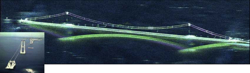
SAR satellites may be a crucial tool for monitoring, due to their ability to provide imaging during nighttime and in all weather conditions.
They are equipped with radar sensors that use microwave energy to penetrate cloud cover and darkness.
The main limitation of SAR imagery is that the current ML algorithms applied for data interpretation are trained on RGB imagery and show poor results when applied to SAR.
The research team have developed a baseline method and pretrained models that enable the use of both RGB and SAR imagery.
EO vs SAR satellites
The EO satellites are not only used in Ukraine. Anyone in the world who has used Google Maps or similar mapping software has, by definition interacted with EO satellite imagery.
SAR satellites can penetrate cloud cover but the manual processing of the vast amounts of data is an engineering challenge. Automating the interpretation process may provide real-time insights and improved accuracy.
Every day hundreds of terabytes of data are being downlinked from satellites to data centers. ML algorithms such as Computer Vision (CV) are largely used to extract knowledge from that huge amount of data.
Current ML methods for data analysis do not work properly with SAR imagery.
Research method and results
During the research, the team used a computer vision technique for learning representations for RGB, SAR (Synthetic Aperture Radar), and co-registered modalities called MAERS (Multi-modal Augmented Encoder-decoder Representation Learning).
The model was evaluated on the BigEarthNet-MM dataset for multi-label classification and the SpaceNet 6 dataset for semantic segmentation.
The results showed that the fine-tuned MAERS outperformed previous results and allow EO and SAR imagery to be used interchangeably for downstream tasks.

The models will be made publicly accessible after a thorough assessment of the qualified researchers.
Security risks
The research team is aware that this technology could be misused. To prevent this, they have designed these models with input from partners who perform intelligence and imagery analysis in humanitarian settings.
Therefore, the released model can only be used for the benefit of humanity after taking into consideration their ideas, observations, and criticisms.
Conclusions, future research
The researchers present a new ML model designed to improve access to SAR imagery.
This approach can be used in the conflict in Ukraine to support several important applications, including the creation of accurate maps of the region, in support of military operations.
It can also monitor changes in the landscape that may indicate the presence of military installations or fortifications.
Future research for SAR imagery may focus on higher resolution imaging systems in order to provide more detailed information about the Earth’s surface.
Learn more:
- Research paper: “Accelerating Ukraine Intelligence Analysis with Computer Vision on Synthetic Aperture Radar Imagery” (on BAIR)
- Further insights: “To maximize Ukraine coverage, BlackSky shifted orbits for its newest satellites” (on BreakingDefense)